Adventures on Maine’s Pequawket Trail Scenic Byway

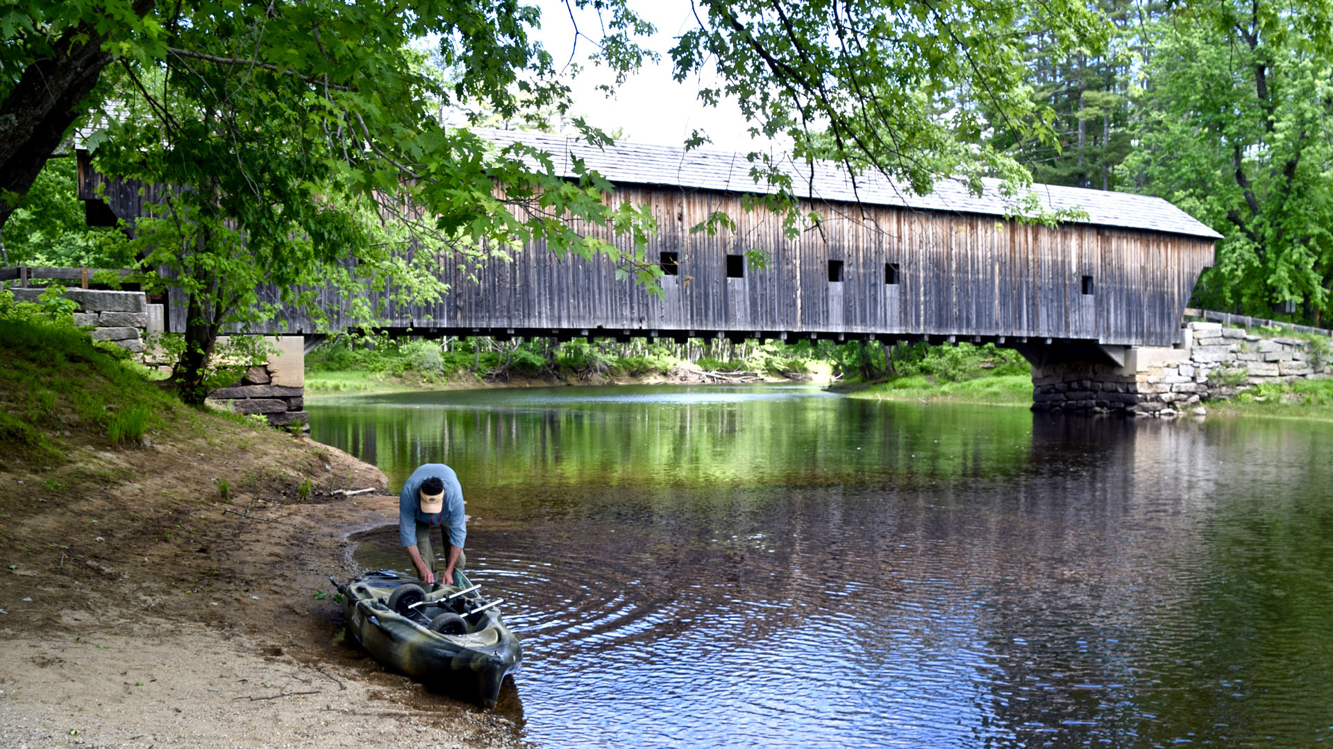
The Hemlock covered bridge outside of Fryeburg, Maine, was built in 1867.
Story and photos by Susan Hegger
Susan is a world traveler and an avid photographer.
Hike, swim or just enjoy the views on this rural route.
The plan looked simple enough: Explore the rural interior of Maine on the Pequawket Trail Scenic Byway. The 60-mile section of state Route 113 begins in Standish, a roughly 45-minute drive from Portland, and ends in Gilead.
But it’s the 30-mile stretch from Standish to historic Fryeburg by the New Hampshire border that offers the most varied stops and attractions. Along the way, this drive promises lakes, rivers, waterfalls and mountains, including scenic views of New Hampshire’s White Mountains. The 30 miles from Fryeburg to Gilead passes through the White Mountain National Forest and is one of the great northeastern autumn drives to see colorful fall leaves.
Because our map wasn’t very helpful with directions, we used phone apps to find some of the points of interest. What we relied on most, though, was our spirit of adventure. We just thought of ourselves as explorers on our own Maine “backwoods” journey through an area of the state that gets far less attention than its more famous coastal drives.
Our drive began in Standish. A detour onto state Route 35 off Route 113 brought us to the boat launch site for Sebago Lake, Maine’s second largest lake.
You may be forgiven for wanting to end your Pequawket Trail road trip right then and there. The lake is breathtaking — clean, clear and a tantalizing azure blue. No swimming or wading is allowed at the boat launch, but public beaches for swimming or fishing are available at other spots along the lake. We made do with watching a few pleasure craft ply the waters and feeling the breeze brush our cheeks.

Sebago Lake is Maine's second largest lake.
Scenic Hiking Trails
The parking turnouts for Steep Falls, our next stop, come almost immediately after the left turn off Route 113 onto state Route 11 and before the bridge over the winding Saco River. We hiked a short trail that meandered along the river to the small but picturesque falls. Most folks were obviously there for the water, the beach and a lazy day.
Not us, though. We were on our mission — although we did pull over for a quick photo of a rusted water tower around Baldwin.
For hikers, the area between Hiram and Fryeburg offers numerous trails of varying lengths and difficulties, enough to keep one hiking for days. We decided to sample the challenging Barnes Trail up Mount Cutler in Hiram. The sign at the trailhead indicated it was roughly a 2-mile hike — very doable — but be prepared for rocky and steep terrain. Remember to wear bug spray, too, to deter the many bugs flying around.
The last Maine town along the byway is charming Fryeburg, which turned out to have two of my favorite stops of the drive.
Beautiful Covered Bridge
Jockey Cap trailhead is on U.S. Route 302, a mile from the intersection with Route 113, and starts behind the Dollar General. The quarter-mile trail to the top of Jockey Cap rock is easy, and the view of the mountains is more than worth it. A curious stone monument also sits at the top, which has a 360-degree “crown” that identifies all the peaks in view. The monument is dedicated to Robert E. Peary, the Arctic explorer, who once lived in Fryeburg.
Five more miles down 302, we came to Hemlock Bridge Road, where we turned left and drove for 3 more miles until we reached the Hemlock covered bridge over the Saco River. Built in 1857, this attractive weathered bridge, a Maine historic civil engineering landmark, still allows cars across it — although I can’t imagine that this remote area has much traffic.
The best thing about the Pequawket Trail is that you can see it as you like — a few hours, a day or a couple of days. Are you out mostly for a drive? Or for a hike or two? Or for a swim in a river or lake? Totally your choice.
Just for grins, we crossed over into New Hampshire. We stopped briefly in the Stowe General Store whose eclectic deli menu ranged from egg salad to massaman curry.
After Stowe, it was back on the road for us, back to Portland and a lobster dinner. Like Robert Frost before us, we had taken the road less traveled — and it had made all the difference.
Related
Read about more scenic drives.
- Surfing on the West Coast
- Road Trip to Hana on Maui
- Vacationing in Maui
- Road Trip on Vancouver Island
- Nostalgic Route 66 Road Trip: Albuquerque to St. Louis
- Jackson, Wyoming, Makes a Great Base for Scenic Drives
- Road Trip to Snowy Range Scenic Byway
- Algonquin Park Scenic Drive
- Pacific Coast Highway - California
- The Great River Road: Missouri to Louisiana
- Road Trip on the Natchez Trace Parkway
- Boulder to Black Canyon of the Gunnison Road Trip
- Road Trip along California's Redwood Coast
- The Great River Road: Minnesota to Missouri
- Road Trip to See Texas Bluebonnets
- 9 Outstanding Scenic Drives
- Cades Cove Scenic Drive is a Trip Back in Time
- Litchfield Hills Loop Road Trip
- Road Trip from New Orleans to Memphis
- Nostalgic Route 66 Road Trip: Santa Monica to Albuquerque
- Pacific Coast Highway - Washington and Oregon
- Road Trip to Hikes along the Crooked Road
- Weekend Getaway to Virginia's Mountains of Music Festival
- Washington’s North Cascades National Park
- Cascades Loop Road Trip
- Nostalgic Route 66 Road Trip: St. Louis to Chicago
- Fall Foliage Road Trip in Road Trip From San Francisco to Yosemite
- Road Trip on Maine's Route 1
- Road Trip Along Mississippi’s Blues Trail
- Road Trip on Maine's Pequawket Scenic Byway
- Isle Royale National Park
- Road Trip to Florida Beaches
- Road Trip on Utah's Scenic Byway 12
- Road Trip on San Juan Skyway
- Sandhills Journey Scenic Byway
- Edisto Island South Carolina Scenic Drive
- South Dakota Black Hills
- Icefields Parkway 3-Day Driving Trip
- Road Trip to Prince Edward Island, Canada
- Road Trip on the Cabot Trail, Nova Scotia

